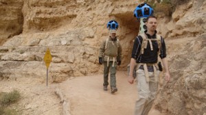
A few weeks ago, specialist teams from Google Street View hiked down to the bottom of the Grand Canyon, carting backpacks with roughly 40 pounds of equipment normally found in Google Street View cars on foot to record what will be the first map entry into the device known Google Trekker. According to Steve Henn's article on NPR, this effort was the first step in Google's goal to digitally record the places in the world where the company's vehicles and bikes can't go.
Despite concerns that high quality Google maps of wild places might encourage otherwise unprepared hikers and explorers to venture out without necessary preparation or experience, the team plans to use software and a variety of specialized tools that will result in "smooth, continuous eye-level view" of global trails and spaces:
It will allow anyone who is online — at home or with a smartphone — to virtually peer down the Bright Angel trail and see the sun stream over the rim of the canyon walls.
This is just the beginning. Google wants to send the Trekker on expeditions all over the world. Team members talk about everything from the Appalachian Trail to Antarctica — and one day maybe even Everest.
For more details, please read the entire article.
